August 31, 2017
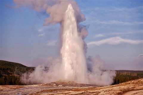
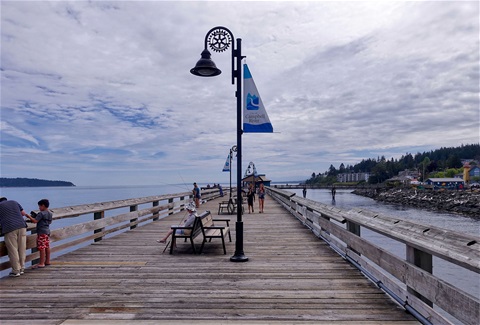
Today we drove to Old Faithful and back (128 km). Here we hiked along a path for about 12 km to see a lot of geysers and pools. The picture shows the eruption of Old Faithful when we watched it the second time.
August 30, 2017
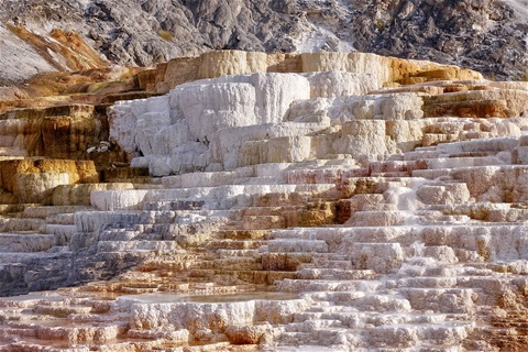
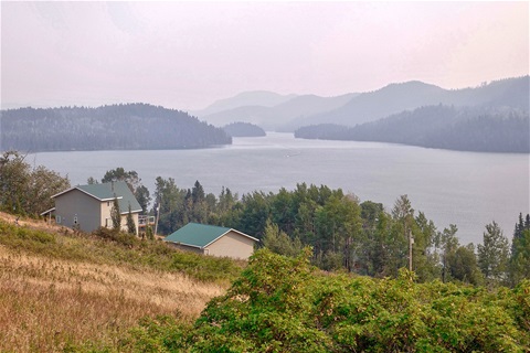
Today we traveled the first time into the Yellowstone National Park. We did the north loop (225 km). We saw 6 Bisons, 1 moose, 3 waterfalls, 1 geyser and limestone terraces. My picture shows a part of the limestone terraces at Mammoth Hot Springs.
August 29, 2017
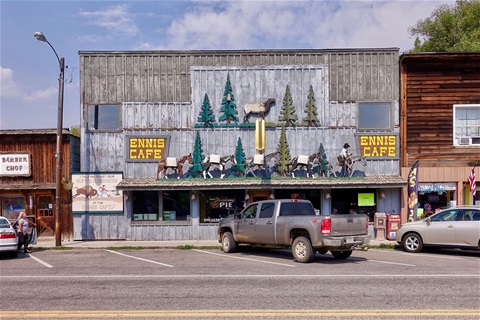
Today we traveled from Butte to West Yellowstone (235 km). Until Ennis (118 km) we traveled under the smoke cloud. Then we saw blue sky again. Ennis's main street looks like a real western town. My picture shows one of the buildings in Ennis.
August 28, 2017
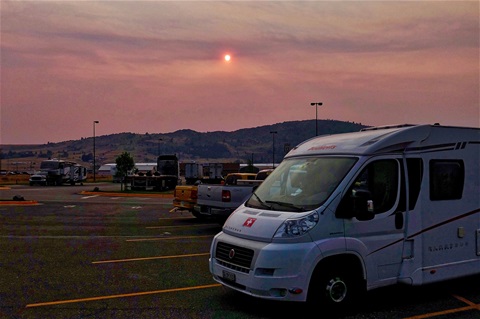
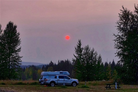
Today we said goodbye to Edith and Stefan and traveled from Kalispell to Butte (352 km). We took the scenic route but didn't see much because there was a wildfire half way to Butte. The smoke darkened the sky on the whole way. A ranger told us that 5 square miles of forest burned down last night. The picture shows how the sun shines through the smoke this evening in Butte. The picture is too dark in order the sun looks like it was in nature.
August 27, 2017
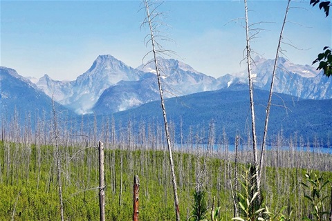
Today we stayed at the campground and planned our journey through the USA. The plan is not finished but we know where to go for the next two weeks. The picture is from our yesterdays trip. It shows the wildfires in the Glacier National Park better as the picture I attached yesterday.
August 26, 2017
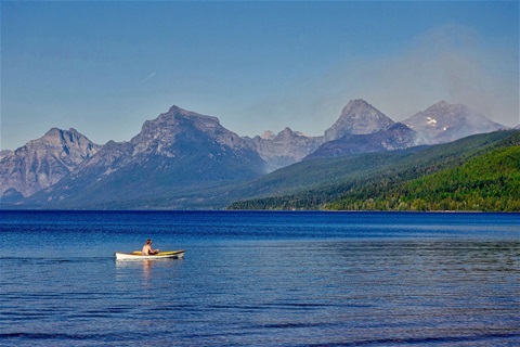
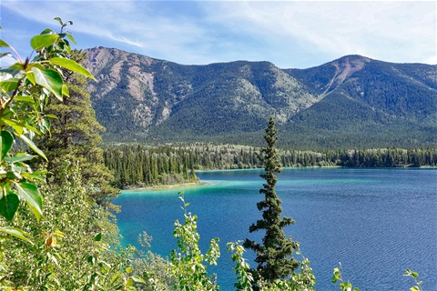
Today we traveled to Polebridge a small village in the Glacier National Park (77 km). On the way, we had a good view of the mountains in the Glacier National Park and the wildfires which are there still burning. On the way back we spend time at Lake MacDonald. The picture shows the lake and the mountains. On the right side, you see a column of smoke from some wildfires.
August 25, 2017
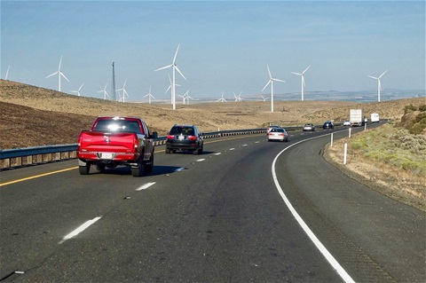
Today we did run some errands. One thing was to let do an oil change at our motorhome. But the company which said yesterday they can do it couldn't find the right oil filter for our European car. This is now my next challenge to find an oil filter which fits our car. Then I organized with the help of Stefan a device which helps us to have better internet connection. On the campgrounds, the signal strength is sometimes very weak in order on some of our devices we can*t reach the internet. I hope this will now be much better with the new device. The picture shows the landscape at Kittitas when we drove from Seattle to Vantage some days ago.
August 24, 2017
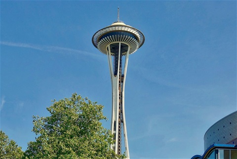
Today was a rainy day. We didn't travel anywhere. We went shopping and chilled on the campground. The photo shows the Space Needle in Seattle, which I took five days ago.
August 23, 2017
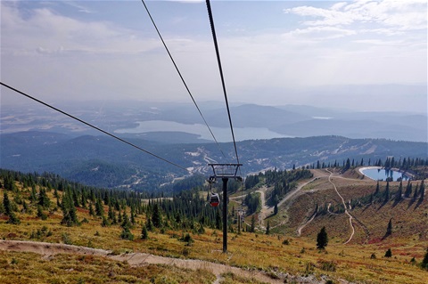
Today we drove to the Whitefish Mountain Resort (35 km). Here we took the chairlift to the summit and did some hiking. Then we had a break in the restaurant and took the chairlift back to the resort. In the Glacier National Park which is not far away are wildfires. Therefore the region is full of smoke. You can see this in the picture I took from the chairlift.
August 22, 2017
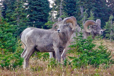
Today we visited the Glacier National Park. We drove through the National Park and went to Many Glaciers on the other side (159 km) and then back. The street through the Park opens beautiful views to many mountains. On the way back we went hiking from the summit of the pass. There we saw a group of four bighorn sheep. They came very near to us. The closest distance was maybe about 10 meters. We followed them and found another group of about 25 animals. That was an amazing encounter. The picture shows the group of four animals.
August 21, 2017
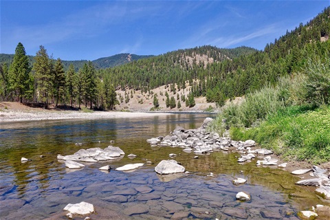
Today we traveled from Osburn in Idaho to Kalispell in Montana (259 km). We drove through woods, over hills, along rivers and lakes. The weather was very nice. It was, therefore, a wonderful drive. In Kalispell, we met Stefan and Edith again. We will spend a week together. The picture shows a river landscape near a place called Donlan.
August 20, 2017
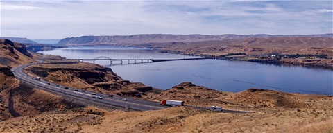
Today we traveled from Vantage in the State of Washington to Osburn in the State of Idaho (354 km). In the beginning of the trip, the landscape was dry and without trees. But there were large corn and wheat fields. With the time more and more trees and mountains were in our sight. The picture shows the Columbia River from the opposite side as yesterday. On the other side of the river (it's more a lake because there is a dam not far down the stream) lays the campground we were last night.
August 19, 2017
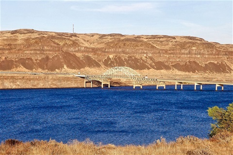
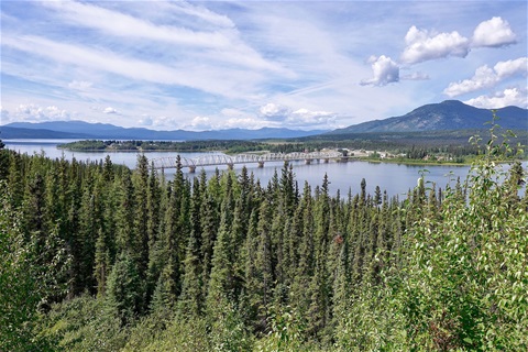
Today we traveled from Bonney Lake north to Seattle and from there east to Vantage (288 km). In Seattle, we wanted to visit the Space Needle. But we couldn't find a parking space. Therefore we drove around it and left Seattle in direction east. We found a campground in Vantage with a very nice view of the Columbia River (barrier lake) and the bridge of highway 90 as my picture shows.
August 18, 2017
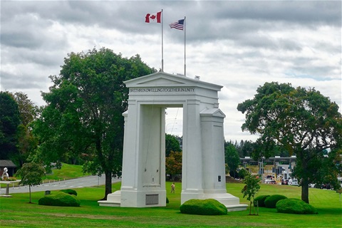
Today we traveled from Vancouver in Canada to Bonney Lake (South of Seattle) in the USA (297 km). With this, we completed our travels in Canada and start traveling in the USA. The picture shows the Peace Park Monument between the Canadian and the USA border control. The USA border control didn't let us import some tomatoes because they were from Ontario.
August 17, 2017
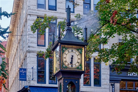
Today we stayed at Vancouver. First, we did some homework. In the later afternoon, we went to town with the bus to do some sightseeing, shopping and have dinner. One of the sightseeing points was the steam clock. Every hour it makes some music by pressing steam through different pipes.
August 16, 2017
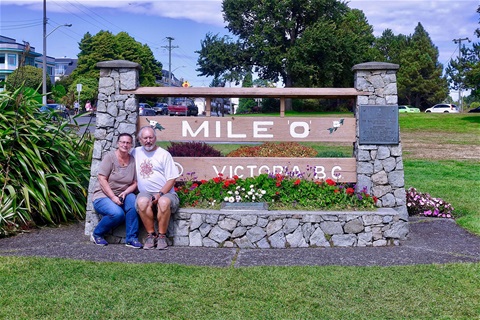
Today we traveled from Nanaimo to Victoria and from here to Vancouver (234 km). We took the ferry from Swartz Bay to Tsawwassen. In Victoria, we visited the End of the Trans-Canada Highway Monument and the harbor area with the Parliment and the Fairmont Empress Hotel. The picture shows us in front of the Trans-Canada Highway monument. With this, we have now really finished our project to drive the TCH from east to west.
August 15, 2017
Today we traveled from Port Alberni to Campbell River and then back along the Strait of Georgia until Nanaimo (304 km). Along the water, we spotted for whales. But we didn't see any. The picture shows the Discovery Pier at Campbell River.
August 14, 2017
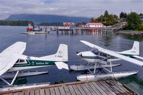
Today we traveled from Port Alberni to Tofino, then to Ucluelet and back to Port Alberni (260 km). We drove on a narrow and winding road through a mountainous landscape to this places. In Tofino, we reached the most western point of the Trans Canada Highway at the Pacific Ocean. Now we have crossed Canada from the most eastern point to the most western point which are reachable by normal roads. The picture shows the port of Tofino.
August 13, 2017
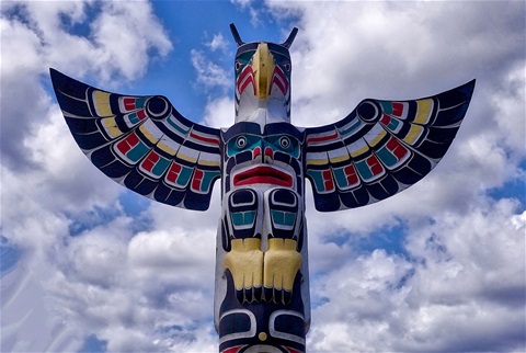
Today we traveled from Duncan to Port Alberni on Vancouver Island (134 km). On the way, we visited the totem poles in Duncan and the murals in Chemainus. The picture shows on part of a colorful totem pole in Duncan.
August 12, 2017
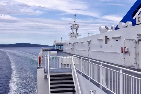
Today we traveled from Merritt to Duncan (422 km). From Tsawwassen Ferry Terminal outside Vancouver to Sidney on Vancouver Island we took the ferry. Then we did a drive through Victoria and went to a campsite in Duncan. The picture shows a part of the ferry.
August 11, 2017
Today we traveled from Quesnel to Merritt (491 km). On the whole way, we traveled under a cloud of smoke. Therefore we couldn't see much of the landscape. The picture shows the situation at Lac La Hache. In the foreground is some sun but in the background, everything vanishes into the smoke.
August 10, 2017
Today we traveled from Houston to Quesnel in British Columbia (419 km). In this area, there were some wildfires in the last days. People told me that there weren't such big fires as this year since a long time. Therefore the sky is full of smoke. It doesn't smell like burned wood. But it darkens the sky. Nice is the sunset. The sun goes down as a big red ball. I tried to show this in my picture.
August 9, 2017
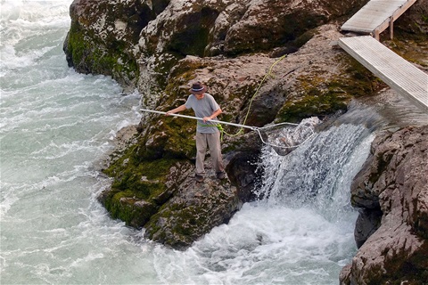
Today we traveled from Hyder in Alaska in the USA to Houston in British Columbia in Canada (397 km). First, we went to see more bears in Hyder. We saw three black bears. Then we drove to Houston. On the way, we visited the Moricetown Falls where humans fish for salmons. Native Canadians since thousands of years did catch salmons at these waterfalls. Today with more modern tools as my picture shows.
August 8, 2017
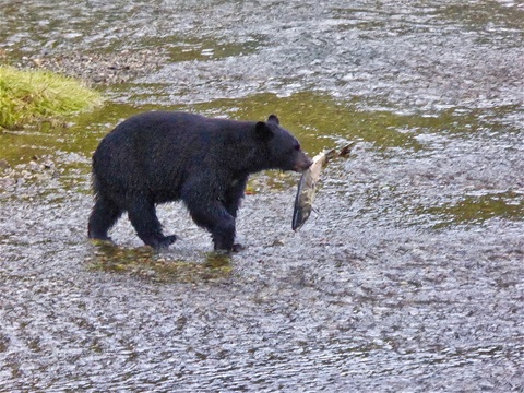
Today we traveled from Tatogga In Canada to Hyder in Alaska in the USA. Hyder is an interesting place. It's the only place in Alaska which can be reached by the road from Stewart in Canada. And you can see bears fishing for salmons for 5 Dollars a person. There is a bear watching platform which is controlled by ranchers. They ask for the 5 Dollars. We saw some black bears and two grizzlies fishing for salmons. My picture shows a black bear with a big salmon in his mouth.
August 7, 2017
Today we traveled from Watson Lake in Yukon to Tatogga in British Columbia (351 km). With this, we left the Alaska Highway and travel now on the Stewart-Cassiar-Highway. Today we saw a lot of woods, lakes, and mountains. The picture shows one of the many such scenes at the PInetree Lake.
August 6, 2017
Today we traveled from Whitehorse to Watson Lake (434 km). We traveled on the Alaska Highway as we did about three weeks ago but in the other direction. Käthi didn't want to rest anymore. She feels that her back is quite OK now. Therefore we traveled. The picture shows the Nisutlin Bay Bridge over the Teslin Lake at Teslin. This is the longest bridge on the Alaska Highway. It is 584 meters (1917 feet) long.
August 5, 2017
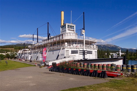
Today we had another day rest in Whitehorse, Canada. In the afternoon we went to town to shop and to visit. In Whitehorse is the sternwheeler SS Klondike put ashore. It was once used to transport freight between Whitehorse and Dawson City. Later it was a cruise ship. Since 1955 it is no more in use. Since 1966 it is at this place ashore and 1967 it became a Canadian National Historic Site.
August 4, 2017
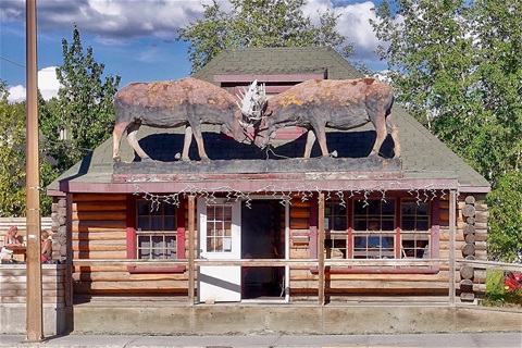
Today we took a rest in Whitehorse. In the afternoon we took the bus to town to do some shopping. Käthi's back is already much better. The picture shows one of the strangest houses I saw in this little town. It's a restaurant with moose on the roof.
August 3, 2017
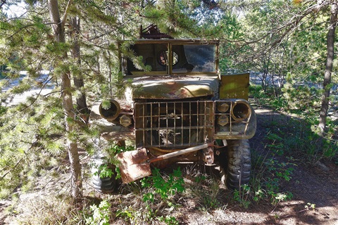
Today we stayed at the RV Park in Whitehorse. Käthi has to rest and me too. We just walked a bit at the RV Park which lays just next to the Alaska Highway. Here we found some old vehicles in the bushes. The US Army just has let them here after the Alaska Highway was built.
August 2, 2017
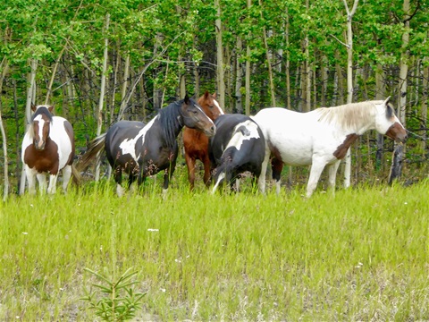
Today we traveled from Haines Junction to Whitehorse (154 km). We went first to the hospital in Whitehorse to see a doctor. The result of the examination was quite positive. The vertebral disks are OK, it's a muscular problem. This can be healed by taking some pills and having some rest. Therefore we will stay some days in Whitehorse. The picture shows some wild horses we saw on the way to Whitehorse.
August 1, 2017
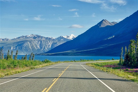
Today we traveled from Tok in Alaska to Haines Junction in Canada (467 km). We traveled on the Alaska Highway as we did about two weeks ago. The border control was without problems. The picture shows a part of the Kluane Lake. Just after we passed Kluane Lake Katharinas back started to hurt. She could hardly walk anymore. Since we were in Nowhereland we couldn't do anything against at the moment. When we arrived at a campground in Haines Junction we asked for a doctor. The answer was that we have to go back 50 km to meet a nurse or go further about 150 km and are in the hospital of Whitehorse. We decided to go to the hospital tomorrow.
Neueste Kommentare
Hallo Mario,
Danke für deinen Kommentar. Ich denke oft an die Zeit mit dir in Lima. Uns geht es gut. Wir wohnen wieder in St. Gallen und können wegen Corona seit einem Jahr nicht mehr reisen. Bis bald
Hallo Erwin, wie geht es Dir und Katharina, ich hoffe gut. Bin nach langer Zeit in Deine Webseite gegangen und hier habt wirklich eine schöne Zeit als "Nomaden" verbracht. Wir bleiben in Kontakt.
Danke, dass euch unsere Band TEARS FOR BEERS am St.Gallerfest 2018 gefallen hat und wir es auf eure Homepage geschafft haben.
Danke für deine immer interessanten Berichte. Ich wünsche gutes Gelingen und einen starken Durchhaltewillen. En Gruess