Zu alt zum Arbeiten, zu jung zum Sterben, gerade richtig zum Reisen. ...........................................................................Too old to work, too young to die, just right to travel.
June 30, 2017
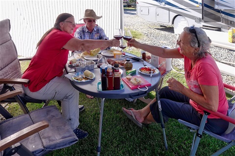
Today we chilled on the campground in Cochrane in Canada. We only went shopping in the afternoon. The picture shows three of the four Swiss celebrating in Canada.
June 29, 2017
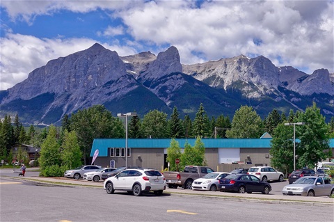
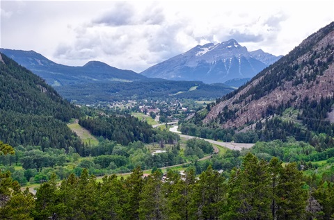
Today we traveled from Canmore to Cochrane (85 km). Canmore is in the mountain region but Cochrane is already on the Prairie. Here we met Käthi's brother and his wife. The picture shows some mountains seen from the city of Canmore.
June 28, 2017
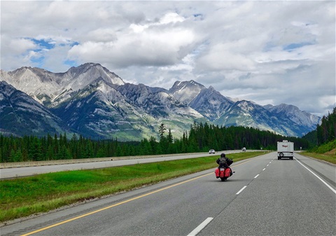
Today we traveled from Canyon Hot Springs in British Columbia to Canmore in Alberta (274 km). We drove about 200 km over two passes and saw a lot of mountains. Unfortunately, the weather was not good and therefore I couldn't shoot nice pictures. Only in the evening in the region of Banff, the weather was better and there I made the attached picture.
June 27, 2017

Today we traveled from Blind Bay to Canyon Hot Springs (165 km). On the way, we visited the cities of Salmon Arm, Sicamous and Revelstoke. The picture shows the Revelstoke River and some mountains south of Revelstoke. Here in Canada are railroads everywhere. All trains we have seen so far are freight trains with most of the times about 100 wagons.
June 26, 2017
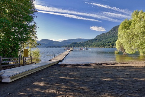
Today we traveled from Penticton to Blind Bay (208 km). On the way, we visited the city of Kelowna. The campground at Blind Bay has a little port. Many Canadians bring their boats with them and go fishing or boating on such lakes. My picture shows the port viewed from the campground.
June 25, 2017
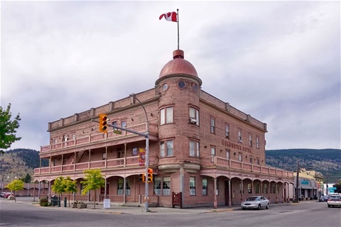
Today we traveled from Cache Creek through Kamloops and Merritt to Penticton (327 km). It was a warm but gray day. The picture shows an old hotel building in Merritt.
June 24, 2017
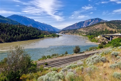
Today we traveled from Chilliwack to Cache Creek in British Columbia (246 km). It was a very nice, sunny and hot day. The highest temperature we measurement was 38 °C. The road followed first the Fraser River and later the Thompson River. The picture shows the junction of these two rivers. The clear water comes from the Thompson River.
June 23, 2017
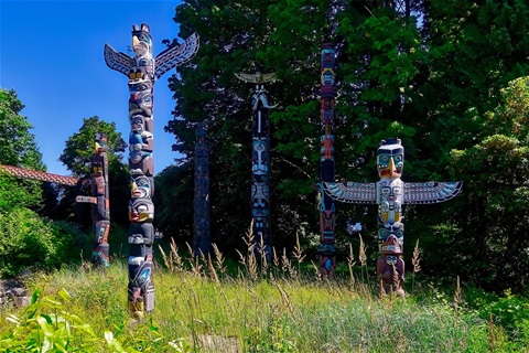
Today we visited Vancouver and in the late afternoon, we drove out of the town to Chilliwack (110 km). We are heading to Calgary now, where we will meet Käthi's brother and his wife. They come up north from Arizona with their motor home. We look forward to meeting them. The picture shows the famous totem poles in the Stanley Park in Vancouver.
June 22, 2017

Today we traveled from Oyosoos to Vancouver (417 km, 7630 km across Canada). With this, we concluded our project to cross Canada from east to west. The TCH would go further with the ferry to Nanaimo on Vancouver Island and then a drive of another 111 km to Victoria. We decided to do this last part when we return to Vancouver in some weeks. The picture shows our RV in front of the ferry terminal at Horseshoe Bay in West Vancouver.
June 21, 2017
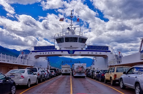
Today we traveled from Creston to Osoyoos in British Columbia (385 km and 7110 from St. John's in Newfoundland). We have another 377 km to go to Vancouver. The drive was through very nice landscapes. We drove along lakes, crossed one and went over three passes. The picture shows our motor home on the ferry over the Kootenay Lake.
June 20, 2017
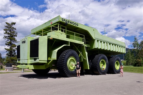
Today we traveled from Crownest Pass in Alberta to Creston in British Columbia (272 km and 6774 from St. John's in Newfoundland). With this, we reached the last state on our journey across Canada. But there are still 710 km to Vancouver. The first city in British Columbia was Starwood. This is a coal mining region. Today it is done in surface mining for what big trucks are used. The biggest truck in the world is on exposition at the tourist information. The picture shows me in front of the Terex Titan.
June 19, 2017
Today we traveled from Medicine Hat to Crownest Pass (316 km). We left the TCH and travel now on the Crownest Trail, which goes parallel to the TCH. We have now done 6504 km from St. John's in Newfoundland. Near Pincher Creek, we saw the Rocky Mountains the first time. And now we overnight on the Crownest Pass in midst of mountains as the picture shows.
June 18, 2017
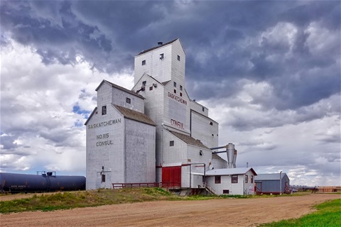
Today we traveled from Swift Current in Saskatchewan to Medicine Hat in Alberta. And we made a tour from Maple Creek to Fort Walsh and Consul (449 km and 6194 on the TCH). Someone told me that there are some ghost towns in the region of Consul. But we couldn't find them. The picture shows the granary of Consul.
June 17, 2017
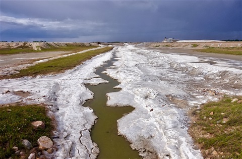
Today we traveled from Indian Head to Swift Current (310 km and 5975 km on TCH). On the way, we visited the RCMP (Royal Canadian Mounted Police or Mounties) Heritage Center in Regina. We wanted to stay in Regina, the capital of Saskatchewan but it was raining. Therefore we decided to travel further. The picture was made in Chaplin. This village lays at the Chaplin Lake which consists of saline water. There is a company which harvests salt by evaporation.
June 16, 2017
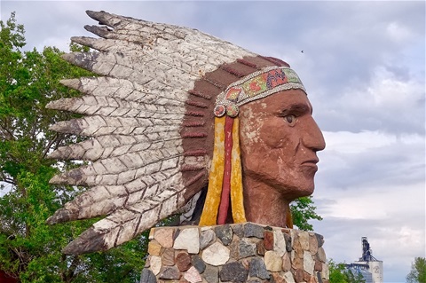
Today we traveled from Winnipeg in Manitoba to Indian Head in Saskatchewan (490 km and now 5668 on TCH). We had to set back the time for one more hour. The landscape is now flatter and wider. The picture shows the Indian Head statue as the landmark of Indian Head.
June 15, 2017
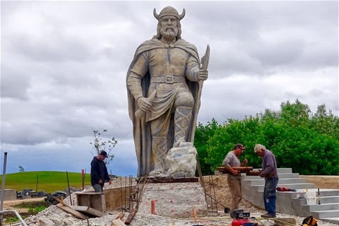
Today we did a trip in Manitoba (222 km). We drove to the Interlake region and visited Lake Winnipeg. There we passed the city of Gimli which was founded by people from Iceland. Therefore they erected a Viking statue as their landmark.
June 14, 2017
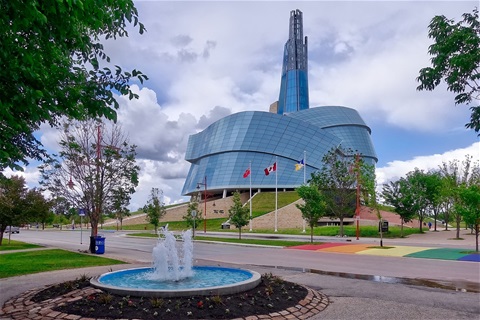
Today we visited different places in and around Winnipeg. The picture shows the building of the Canadian Museum for Human Rights. The people here call it the ham.
June 13, 2017
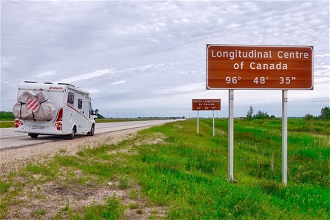
Today we traveled from Dryden to Winnipeg (338 km, and now 5143 km on the TCH). Shortly before Winnipeg, there is a sign at the street which tells us that we are now in the center of Canada. It seems that the road is longer in the east than in the west since we drove already 5143 km of the total of 7300 km. Or I have a wrong number of the total length of the TCH!
June 12, 2017
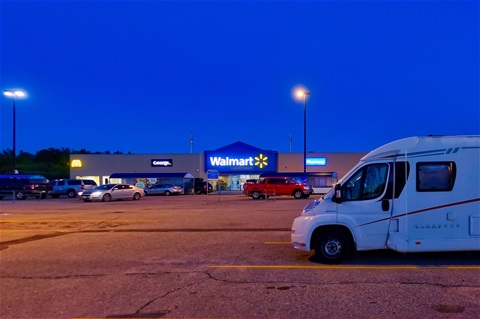
Today we traveled from Thunder Bay to Dryden (351 km, now 4804 km on the TCH). The road led through woods and along with many lakes. Tonight we camp on the parking lot of the Supermarket Walmart. Some of their stores allow staying for one night in their parking lot for free. This is good to save some money. The picture shows our motor home in the parking lot of Walmart in Dryden.
June 11, 2017
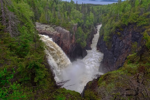
Today we traveled from Wawa to Thunder Bay (480 km). Now we have done 4460 km on the TCH. We drove on a hilly road through woods and passed many lakes. There are only a few small towns along this road. The picture shows the Aquasabon waterfalls and gorge near Terrace Bay.
June 10, 2017
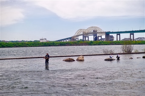
Today we traveled from Spragge to Wawa in Canada (388 km). We traveled now 4053 km on the TCH. This means we did halfway to Vancouver. On the way, we visited the city of Sault Ste. Marie. Here Lake Superior and Lake Huron are only divided by rapids of about 500 m length and a level difference of 6 meters. These rapids are not navigable. Therefore there are locks on the Canadian and the US side. My picture shows these rapids, where fishermen stay in the water on the Canadian side. At the wall in the water is about the border between Canada and USA. Behind the shore is the USA lock. And there are bridges to connect both countries.
June 9, 2017
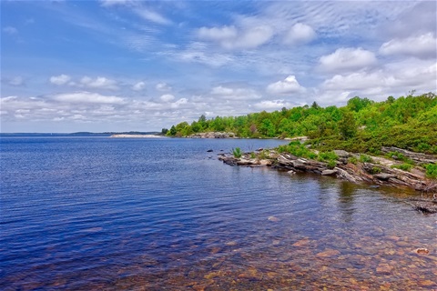
Today we traveled from Barrie to Spragge (425 km). On the TCH we traveled now 3590 km. This was the third day in a row with very nice and warm weather. Today I wear the first time shorts in Canada. The picture shows the Parry Sound.
June 8, 2017

Today we traveled from Toronto to Niagara Falls and then up north to Barrie (338 km). Now we have done 3163 km on the TCH. The picture shows the American Fall (left) and the Canadian Fall (right) at Niagara Falls.
June 7, 2017
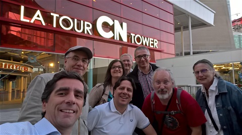
Today we traveled from Kingston to Toronto (270 km). With this, we traveled 3095 km on the TCH. In Toronto, we met friends from the ISO/TC 130 meeting. Together we climbed the CN Tower. The picture shows us with some of my ISO friends.
June 6, 2017
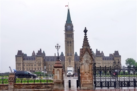
Today we traveled from Montreal to Kingston in Canada (394 km). With this, we drove now 2831 km on the TCH. On the way, we traveled through Ottawa. But since it was raining and there was heavy traffic, we didn't stop for visiting. The picture from the parliament was taken out of the motor home.
June 5, 2017
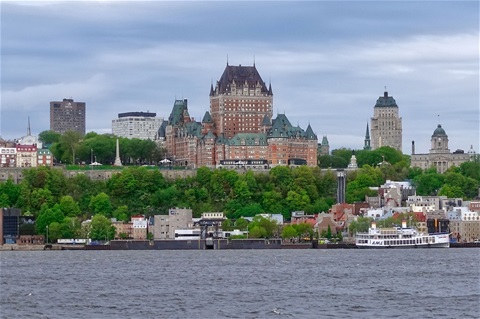
Today we traveled from Québec City to Montreal (303 km). This means we have made 2541 km on the TCH now. Today was a rainy day. When we arrived in Montreal there was heavy raining. Therefore we couldn't visit Montreal. Instead of visiting we went to a campground, cooked there and used the internet. Last night we slept at the Saint Lawrence River on the opposite shore of Québec City. We were allowed to be there until 7 am. I got up at 6.30 and made this picture from the river and the old city of Québec.
June 4, 2017
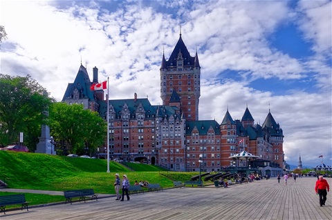
Today we traveled from Edmundston to Quebec City in Canada (310 km). After five days we drove 2287 km on the TCH. Today we arrived in the State of Quebec. We felt a great difference to New Brunswick. The streets are better, there are rest areas at the highway, the landscape is wider and more beautiful and we didn’t see so much very fat people. The picture shows the Château Frontenac, a hotel which is more than 100 years old. I was here some 20 years ago for a TAGA conference. And together with Käthy, we visited Quebec 37 years ago, a year before we married.
June 3, 2017
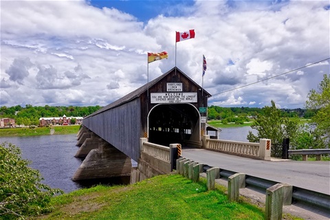
Today we traveled from Moncton to Edmundston in Canada (427 km). After 4 days on the TCH, we have traveled 1982 km. On the way, we visited the longest covered bridge in the word (391 m) at Hartland and the waterfalls at Grand Falls. The picture shows the longest covered bridge.
June 2, 2017
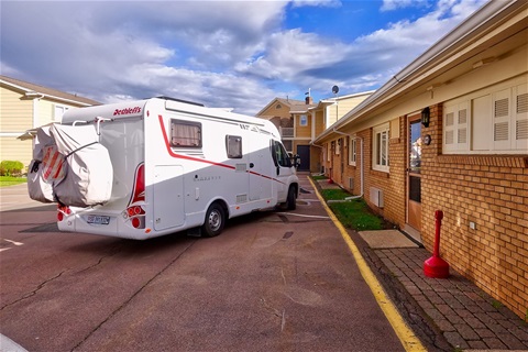
Today a miracle happens! The part for our motorhome arrived here in Moncton after 15 days of traveling through the world! At the same time, the second shipment left the workshop in Switzerland today too. I tried to stop this shipping. I don't know if this was successful yet. At 5 pm our motorhome was repaired and we could get it. Therefore we are traveling again tomorrow. The picture shows our motorhome in front of our motel room.
June 1, 2017
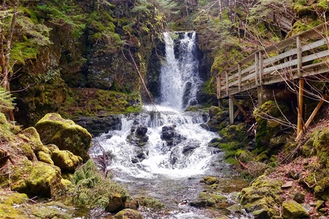
Today was my administrative day. I moved the office from the motor home to the hotel to check the accounts and pay the bills. The picture shows the Dickson Falls in the Fundy National Park. I made this picture about two weeks ago.
Neueste Kommentare
20.01 | 23:20
Hallo Mario,
Danke für deinen Kommentar. Ich denke oft an die Zeit mit dir in Lima. Uns geht es gut. Wir wohnen wieder in St. Gallen und können wegen Corona seit einem Jahr nicht mehr reisen. Bis bald
19.01 | 23:43
Hallo Erwin, wie geht es Dir und Katharina, ich hoffe gut. Bin nach langer Zeit in Deine Webseite gegangen und hier habt wirklich eine schöne Zeit als "Nomaden" verbracht. Wir bleiben in Kontakt.
26.09 | 11:47
Danke, dass euch unsere Band TEARS FOR BEERS am St.Gallerfest 2018 gefallen hat und wir es auf eure Homepage geschafft haben.
12.05 | 17:39
Danke für deine immer interessanten Berichte. Ich wünsche gutes Gelingen und einen starken Durchhaltewillen. En Gruess
Diese Seite teilen